Translate

Sunday, April 13, 2014

Einsteins Problem

Einstein's problem


There are 5 houses in 5 different colours. In each house lives a person of a different nationality. The 5 owners drink a certain type of beverage, smoke a certain brand of cigar, and keep a certain pet. Using the clues below can you determine who owns the fish?
The Brit lives in a red house.
The Swede keeps dogs as pets.
The Dane drinks tea.
The green house is on the immediate left of the white house.
The green house owner drinks coffee.
The person who smokes Pall Mall rears birds.
The owner of the yellow house smokes Dunhill.
The man living in the house right in the middle drinks milk.
The Norwegian lives in the first house.
The man who smokes Blend lives next door to the one who keeps cats.
The man who keeps horses lives next door to the man who smokes Dunhill.
The owner who smokes Blue Master drinks chocolate.
The German smokes Prince.
The Norwegian lives next to the blue house.
The man who smokes Blend has a neighbour who drinks water.

ok to make things clear, everything needed to get to the solution is given, there is no hidden logic, it is a matter of elimination, trial and error, this is probably the easiest way to get to the solution in my opinion, 

try solving it yourself, the solution is below, not very easy to follow the explanation but i tried, all you got to do is find the right angle to tackle this puzzle! have fun!


 1. the first thing to do is to create a table where you can write down the facts

2. jot down all the obvious facts


the norwegian lives in the first house,and lives next to the blue house,the person living in the middle drinks milk,
what cannot be placed in the table but are facts should be written on a piece of paper and deduced and eliminated
the brit lives in the red house, the swede owns dogs the green house owner drinks coffee and so on. 
next easy step is to figure the color of each house, the blue house is the second, the green house is on the left of the white house and the green house owner drinks coffee so the green and white houses have to be placed last.

Im only giving you the table, fill it out..... i know this is cruel but I don't give a crap, suffer!!! ok there is a bad explanation of the method below


color

blue


nationality
norwegian


beverage


milk


cigar


pet


the brit lives in the red house, and the norwegian lives next to the blue house so the brit lives in the middle, this leaves the yellow house for the norwegian, the colors are done! also the owner of the yellow house smokes dunhill. 


the man who keeps horses lives next to the person who smokes dunhill, so it has to be the blue house


the man who smokes blend has a neighbor who drinks water, the man who smokes blend lives next to the man who keeps cats, here you may apply a trial and error and then cross check with the clues you'll figure that the cat owner drinks water, so the norwegian gets it( i skipped some steps coz im too lazy, or im having a tough time explaining right now!)


the guy who smokes blend has a neighbor who drinks water, so the blue house smokes blend


now we apply some more trial and error and logic to figure out that the swede may live only in the last 2 houses, to skip more steps let the swede take the last house and he keeps dogs, so with this probability we can put the dane in the blue house since he drinks tea! so then the swede must be the chocolate drinker


so now the guy who drinks chocolate smokes bluemaster, the german therefore must live in the green house and he smokes prince, so the brit has to be smoking pall mall, and the guy who smokes pall mall rears birds so the german has got the fish!!! woohoo!!!


Wednesday, April 9, 2014

AN ALL INDIA MOTORBIKE RIDE, PLANNING PHASE! UPDATED APRIL 12TH 2014

A fine line separates genius from insanity, a fine line separates stupidity from bravery.

The greatest minds are those who do not fear the unknown, to keep moving forward when everyone else is stuck.

This is for those who stand by what they believe, for those who are hit so hard by pure truth that there is nothing else, for those with the conviction that what they do matters and will change the way we think and live, for those little ideas that shook the world. This is for those whose dreams will not let them sleep.This is for those who died trying.

here's a quote about the purpose of life

"to see the world, things dangerous to come to, to see behind walls, to draw closer, to find each other and to feel, that is the purpose of life."

The plan is in motion it will take it's time, INDIA HERE WE COME!!!

If you would like to join us please contact the author of this blog,  feel free to comment, keep logging on for updates!

April 12th 2014,

Here are the planned routes and destinations with distances and estimated riding time
We all met as friends here in Mangalore so thought it would be fitting if we started from here!

MANGALORE - KOCHI, 424 KM, 9hrs 44 mins

KOCHI - TRIVANDRUM, 203 KM, 4hrs 15mins

TRIVANDRUM - KANYAKUMARI, 85 KM, 2HRS 12MINS

KANYAKUMARI - RAMESHWARAM, 300KM, 4HRS 50MINS

RAMESHWARAM - THANJAVUR, 237KM, 4HRS 7MINS

THANJAVUR - PONDICHERRY, 166KM, 3HRS 33MINS

PONDICHERRY - MAHABALIPURAM, 96KM, 1HR 39MINS

MAHABALIPURAM - CHENNAI, 52KM, 1HR 17MINS

CHENNAI - HYDERABAD, 629KM, 9HRS 57MINS

HYDERABAD - VIJAYAWADA 272KM, 4HRS 1MIN

VIJAYAWADA - YANAM, 215KM, 3HRS 33MINS

YANAM - VIZAG, 185KM, 3HRS 17MINS

VIZAG - PURI, 445KM, 6HRS 49MINS

PURI - KONARK, 35KM, 34MINS

PURI - KOLKATA, 493KM, 7HRS 39MINS

KOLKATA - SILIGURI, 583KM, 10HRS 58MINS

SILIGURI - SHILLONG, 533KM, 9HRS 25MINS

SHILLONG - DARJEELING, 596KM,  10HRS 30MINS

DARJEELING - KATHMANDU, 620KM, 12HRS 26MINS

KATHMANDU - VARANASI, 502KM, 9HRS 10MINS

VARANASI - KANPUR, 329KM, 4HRS 37MINS

KANPUR - NAINITAL, 378KM, 6HRS 4MINS

NAINITAL - BADRINATH, 367KM, 6HRS 35MINS

BADRINATH - GANGOTRI, 418KM, 9HRS 18MINS

GANGOTRI - KAZA, 652KM, 12HRS 55MINS

KAZA - KOMIK - KAZA, 80KM, 2HRS

KAZA - KULLU MANALI, 205KM, 4HRS 12MINS

KULLU MANALI - LEH, 474KM, 13HRS 36MINS

LEH - KARGIL, 215KM, 4HRS 11MINS

KARGIL - SRINAGAR, 204KM, 4HRS 8MINS

SRINAGAR - JAMMU, 295KM, 5HRS 11MINS

JAMMU - AMRITSAR, 210KM, 3HRS 42MINS

AMRITSAR - WAGAH, 29KM, 30MINS

AMRITSAR - CHANDIGARH, 229KM, 3HRS 48MINS

CHANDIGARH - DELHI, 245KM, 3HRS 52MINS

DELHI - AGRA, 223KM, 3HRS 11MINS

AGRA - JAIPUR, 238 KM, 3HRS 53MINS

JAIPUR - AJMER, 131KM, 1HR 54MINS

AJMER - UDAIPUR, 270KM, 4HRS 22MINS

UDAIPUR - AHMEDABAD, 256KM, 3HRS, 45MINS

AHMEDABAD - VALSAD, 336KM, 4HRS 43MINS

VALSAD - MUMBAI, 195KM, 3HRS 57MINS

MUMBAI - MALSHEJ GHAT, 131KM, 2 HRS 40 MINS

MALSHEJ GHAT - PUNE, 115KM, 2HRS 16 MINS

PUNE - PANAJI, 437KM, 7HRS 34MINS

PANAJI - MANGALORE 377KM, 7HRS 22MINS


A TOTAL OF 14999KMS, APPROXIMATELY 249.98HRS OF RIDING TIME OR 10.41 DAYS ON A MOTORBIKE!!! WE ARE LOOKING AT A MINIMUM OF RS 500,000 IN SPENDING FOR THE ENTIRE TRIP PER HEAD, THIS INCLUDES EVERYTHING FROM RIDING GEAR TO MISCELLANEOUS EQUIPMENT, HOTELS AND FOOD!!!!


Kumaraparavathu hike, jan 26 republic day in India


Kumaraparavathu jan 26 2014, republic day


the little green gate, the trail starts here
Probably the most famous trekking route in Karnataka, two peaks to conquer 12 kms of endurance testing trails. located at the town of Kukke Subramanya in South Canara a little temple town mostly visited by pilgrims and devotees.
Thats where we were headed
Dr Ullas and me initially planned to go to a waterfall called Bandaje, however the plan changed the previous night, and Dr Ullas wanted to do the trek that he had once done 10 years ago. Most would complete this trek in two stages with a night halt about 7 km from the peak, but as macho guys we had to complete it that day itself because work beckoned the next day, not many people understand the need to hike,  its a passion and you just do it for the heck of it, no one explored the unexplored with the primary reason of some cause, you do it for the heck of it! the cause is secondary, the adventure is what lives on in memories.January in the sweltering heat is not a good time to hike here it is quite painful and not at all enjoyable the only thing pushing you is your determination not to lose to the heat( not a wise way to stay focussed). The best time to hike here is just after the south west monsoon.What you need to complete the trek is plenty of water, sugary drinks and salty meals,sunscreen and a hat,a good pair of sneakers (mine ripped at the front a result of overuse!) for the weather that we encountered and of course a dumb focus.


We started from mangalore as usual at 0500 hrs took the KSRTC bus to kukke subramanya which is about 90km east. We started the hike at 0830hrs after  little breakfast from the town.there are two trekking routes to the peak 1 from the Somwarpet side 2 from Subramanya Since Subramanya was closer and fit into our estimated time took this route, for your knowledge this is the tougher route, majority would climb the Somwarpet route and head down via the Subramanya rote, there are different permutations ,combinations to the route not very complicated,figure it out.

 The trail route stars at a little green gate about 1km from the town you can easily walk the distance or take an auto-rickshaw to that point. The trail for the initial 3 km is lined by trees(mostly strychnine nux vomica) which are part of the

forest, the Pushpagiri wildlife sanctuary. The trail is a gradual ascent and continues this way for the entire hike, there’s hardly any flats so you’ll have to take measured breaks to avoid cramping, rehydrate often as the trail gets steeper and steeper further up, the trees  disappear and you are at the mercy of the sun which burns down unforgivingly. 
forest check post

At the halfway mark you come to the forest check post  where you can leave any extra weight and refresh yourself,  you have to enter your name in a book with your contact details, this is mainly for those who halt for the night, on the way back you have to check with them again.There is a homestay at the same spot as the forest check post for overnight stay.Along the trail from this point on you will find a pond,the water was pretty nasty looking so we didn’t cool off here, then for those who do the overnight hike there are numerous camping areas, you’ll spot these because of the
the homestay
remaining ash  from fires and plastics thrown around( DO NOT LITTER, IT IS A VILE AND REVOLTING HABIT)  you get to hike around the Shola forests if you are lucky you may see some wildlife, we did not see anything significant except for a little viper slithering across the trail. 
You will reach a Mantap along the route, this is approximately 3.5 km from the peak, you will hike to the smaller peak called Sheshaparavathu and then from here 1.5km to Kumaraparavathu, not much of a view at the top, only the

original temple which distinguishes itself as a pile of rocks stacked on each other to make 4 walls, no roof, we found the national tricolor at the peak since it was republic day!The hike to the peak may take between 3.5 to 4 hours if you keep at a decent pace. But I would advice to take your time and enjoy. The way down we pretty much ran, we met trekkers who had been 1 hr ahead of us we reached the town in 2.5 hours, we were back to catch the 1630 hrs bus from KSRTC Subramanya to mangalore! enjoy the photographs!!


kukke subramanya town with kumaraparavathu peak in the background

Saturday, December 21, 2013

Kudremukh National Park, Kudremukh, Karnataka


Brief History


Kudremukh national park is located in the Dakshina Kannada and Chikmaggalur districts of Karnataka. It is a Hikers paradise, a  biodiversity hotspot in the western ghats (mountain range in south India) it was declared a national park by the Govt. of Karnataka in 1987.
The area previously mined for Iron Ore by the KIOCL company has since stopped its activities in 2006 by court order.

The Journey
We started from mangalore on the 4th of december(best time to hike here December to March) at 1430hrs on 2 motorbikes( trust me there is nothing as fun as a motorbike ride!), 4 hikers. The road from mangalore to kudremukh is pretty straightforward, unless you are a complete moron or live in some godforsaken land and never heard of google? its hard to lose your way, and in the days of GPS its almost unheard of (Thanks Google!). The ride is approximately 110KM long and should take about 2.5hrs depending on the traffic, and of course the speed of the motorbikes! The roads as of now in 2013 are well paved and comfortable to ride. The route we took was Mangalore-Moodbidri-Karkala-Kudremukh, here's the link from google maps


The HIke To the Peak
like i mentioned before we started in the afternoon of the 4th of dec, along the route mentioned  above when you reach kudremukh you'll stop at a forest check post where you have to pay an entry fee of Rupees 275 per vehicle, mind you that you have to reach here before 1800hrs otherwise no permission to enter the national park. From here the winding curvy ghat roads begin, any motor biker would have fun! once the ghat roads are dealt you reach see major landmarks like the abandoned KIOCL mining company, the huge Lakya Dam which is almost dry and has only a sludgy sediment left and cows grazing on the walls overgrown by vegetation.

Unmistakable KIOCL mining company

Lakya Dam

The next Forest checkpost is where you have to leave your vehicle and take a 4x4 jeep also you register the names and total number of hikers here, there is a minimal threat from naxals, theoretically a motorbike with a single rider would make it to the top, but from here only the jeeps are allowed. The road winds to the top of a hill about 9KM the roads are really bad and rough if you don't hold on you will easily be thrown out of the 4x4. We reached the home-stay at 1800hrs, you can book these places for an overnight stay for around Rs 800 per head, this includes a room,  sleeping mat, quilt and food, the details for the 4x4 and home-stay are at the bottom of the page, contact them before you plan a hike here!!


a really stupid way to drink water, but a cool photograph just zoom in and see!
limbering up!
Dinner is served, steaming hot chicken with roti and rice!
home-stay


After dinner get to an open area under the night sky and gaze at the ocean of stars above, interspersed with the occasional shooting star and comets, to a city dweller this sight is instantly etched into memory.


limbering up!

The hike

Woke up at  600hrs decided to get ready to leave by 730hrs after a heavy breakfast of course! We knew that keeping tome was essential if we had to enjoy the hike enough and be back in mangalore just before dinner. The plan was to reach the peak in a timing of 3 hours spend  hours there and then assuming the hike down would be faster, to reach the home-stay by 1430hrs have lunch then take the 4x4 to where we parked the motorbikes overnight and head back to mangalore. Everything went perfect to the plan!
Hikers usually would take 4 hours to the peak with a guide whom you can hire for RS 500, we decided not hire a guide since we where used to doing things ourselves and a bit of arrogance!
what you'll need: 1 liter water per hiker some food to munch along a jacket to protect from the wind at the peak(optional! but cool)
a really stupid way to drink water, you can collect water from the perennial streams 
The route starts from behind the homestay, the total distance is measured as 9 KM to the peak from the first mile marker which you will see along the route, its an unmistakable pile of rocks with the distance painted in blue (in english).
the trail takes you through the winding hillside down to the streams which you'll have to cross to get to the continuation of the trail through some tall grass then the peak comes into view, a flat faced point highest up in the sky.

The peak


The first parts of the trail takes you through previously cultivated lands the evidence being terrace formations several guava trees springing up regularly the occasional rose plants, the first major landmark along the trail is Lobo house, its a pile of rubble now,you should be here by the 3 KM mark. The next major landmark is onthimara( single tree) the trail is pretty easy till here, from here on-end its a gradual slope progressing to get pretty steep till you reach the flat of the peak. The trail which is visible for miles justified the decision not to take the help of a guide, besides we had the company of a puppy dog that followed us for the entire hike!
our animal guide!


onthimara, the big tree on the right of the photograph,the peak in the background

Along the trail look for wildlife, you may see langurs, gaur( indian bison), sambha deer, spotted deer, wild dogs, hogs , if you're in luck the major predators like leopards and if you're really really lucky a tiger, recent census spotted 4 tigers in the area. the hills are interspersed with the Shola forests( large open areas surrounded by dense forest. Enjoy the wildlife, do not disturb, it may end badly for you!! there's a cuople of photographs of wildlife further down enjoy!

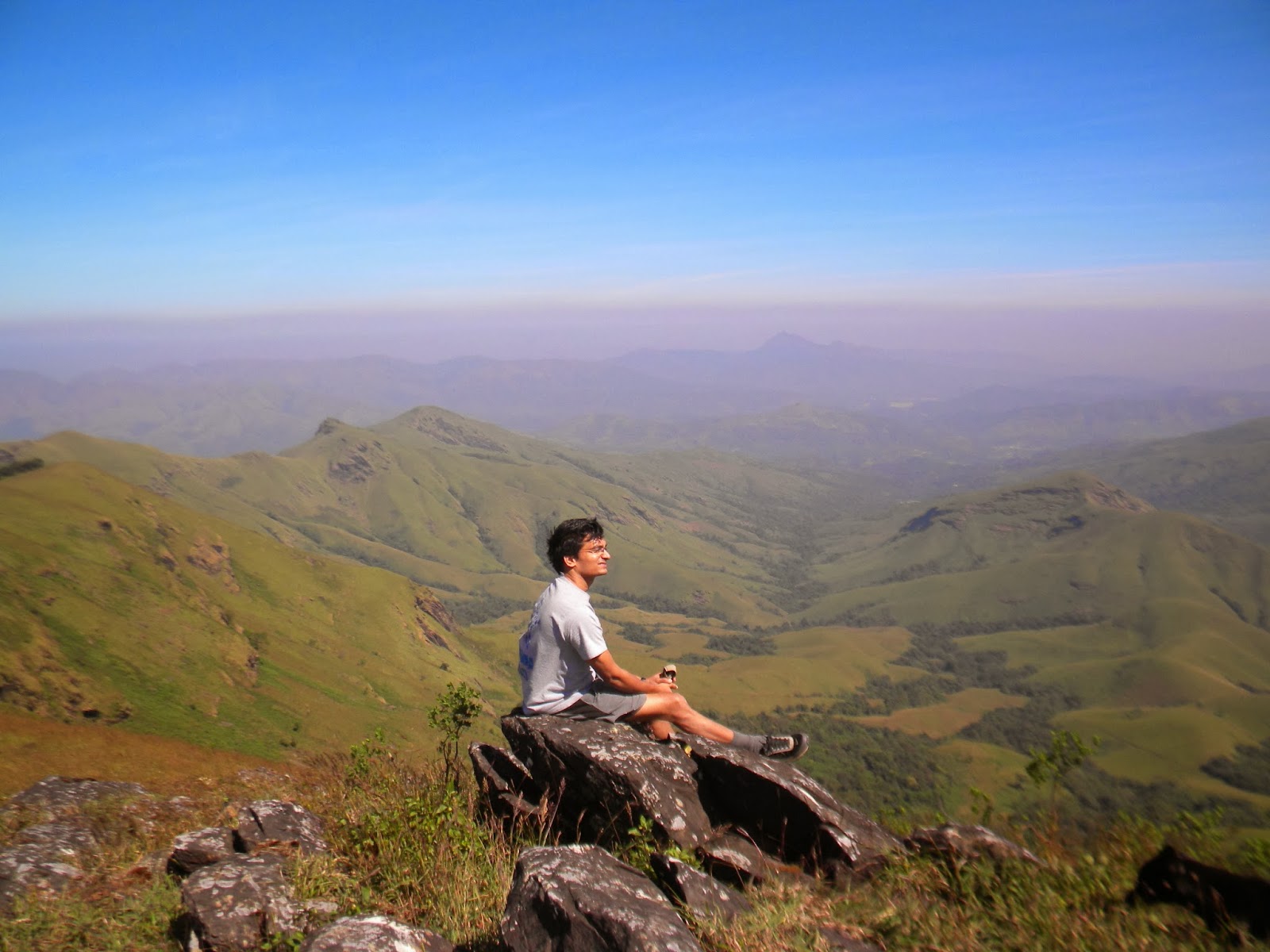
At the peak all you have to do is take a deep breath and marvel at the view! other than good photographs  there is an abandoned church to explore just off the trail and apparently there is a small fort, however we did not explore it because of the time constraints, too bad for us!


Taking a water break at onthimara
the abandoned chueh


A herd of deer seen in the deep center of the photograph

a sambha deer running away from us,try to find it, camouflage! 


hoof prints 


drinking water!

this is for Karthicks girlfriend if you ever read this!


the valley below, vieweed from the edge at 1892 meters


Shola forests


the pool jump

 Super-man pose

Spider-man pose


the hikers from left to right; Karthick, George, Dileep, Dr.Ullas


NO idea how Dr  Ullas phone picked up service here!!great network?


Terrace farming


 Rajappa with his kids
DETAILS FOR HOME-STAY 

CONTACT RAJAPPA AT MULLODI HOUSE,SOMAVATHI WATERFALL
PHONE 08263 249333
MOBILE: +91 9481179008, +91 9483983324


 FOR 4X4 
CONTACT RAVI 
MOBILE: +91 8762435933